A tropical depression is the weakest, most formative stage of a tropical cyclone - the spinning storm system that, given the right conditions, can strengthen into a tropical storm or a full-blown hurricane. The term captured attention in July 2020 when Tropical Depression Edouard spun up over the open Atlantic and, less than two days later, strengthened into Tropical Storm Edouard, becoming the earliest fifth named storm on record. Edouard never threatened land as a major system, but its brief life offers a clear, real-world look at how tropical depressions form, how they are classified, and why some fizzle while others grow into hurricanes.
What Is a Tropical Depression, Exactly?
According to the National Hurricane Center (NHC), a tropical depression is a tropical cyclone whose maximum sustained surface winds measure 33 knots or less - about 38 mph (62 km/h) or lower, using a one-minute average. It is the lowest official classification on the tropical cyclone scale, sitting below a tropical storm and a hurricane. The word "depression" refers to the drop in atmospheric pressure at the storm's center, which is what drives air to spiral inward.
Meteorologists group tropical cyclones into four broad stages of development:
- Tropical disturbance: a cluster of thunderstorms with some organization but no closed circulation.
- Tropical depression: a closed circulation with maximum sustained winds of 38 mph (62 km/h) or less.
- Tropical storm: sustained winds between 39 and 73 mph (63-118 km/h); this is also when the system gets its name.
- Hurricane: sustained winds of 74 mph (119 km/h) or higher.
A closely related term, a subtropical depression, describes a hybrid low-pressure system with both tropical and non-tropical traits, but with the same 38-mph-or-less wind ceiling. The key difference is that a tropical depression is a warm-core system powered by heat from the ocean, while subtropical systems also draw energy from temperature contrasts in the atmosphere.
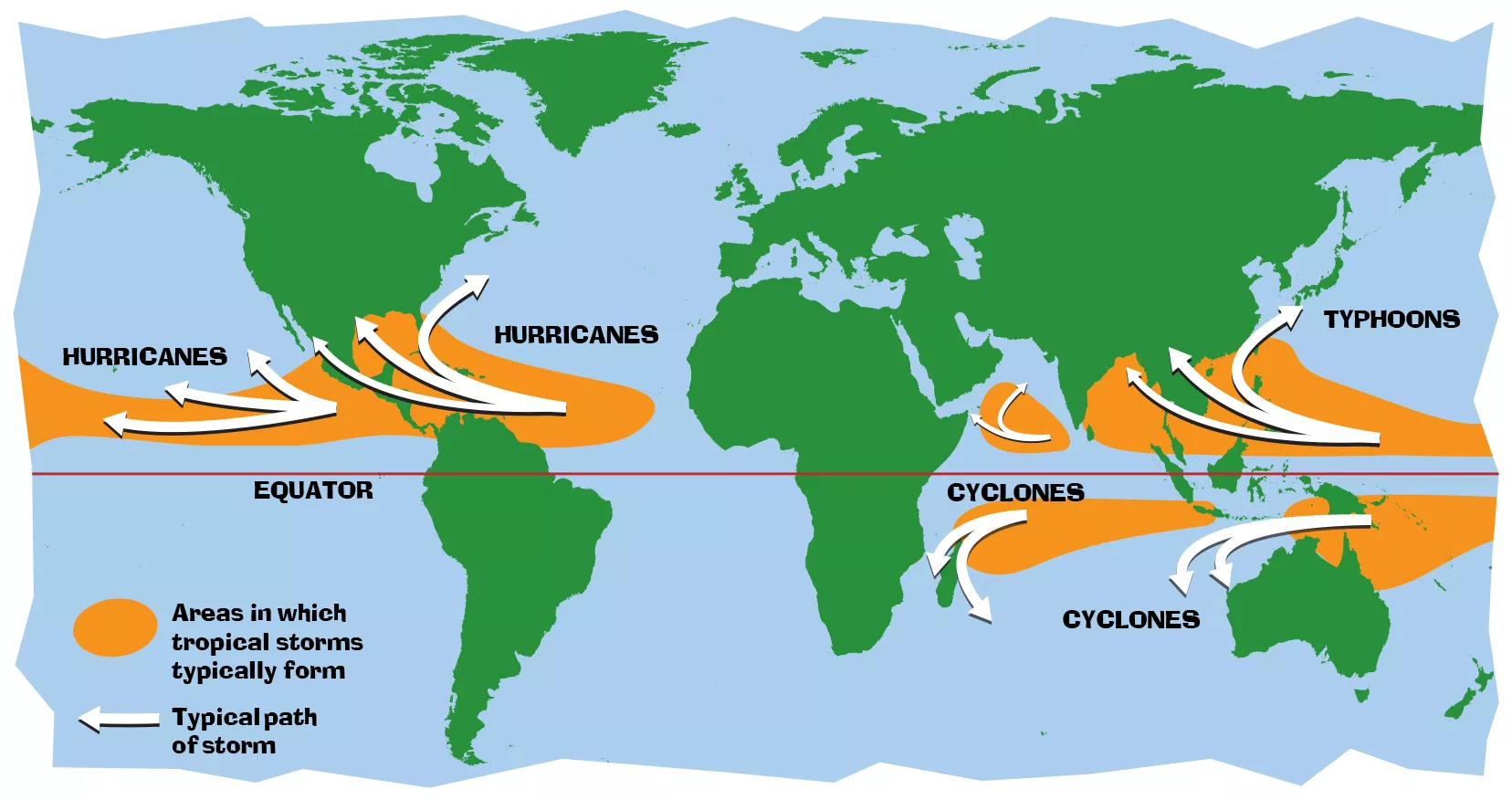
From Depression to Named Storm: Edouard's Brief Life
Edouard began, as many Atlantic systems do, from a weak frontal boundary rather than a classic tropical wave. Here is how the short-lived storm unfolded:
- July 4, 2020: A tropical depression formed roughly 290 miles west-southwest of Bermuda.
- July 5: The depression passed about 70 miles northwest of Bermuda around 08:00 UTC, producing wind gusts up to 43 mph (68 km/h).
- July 6: Moving northeastward, the depression strengthened into Tropical Storm Edouard, reaching peak winds of 45 mph (72 km/h) and a minimum central pressure of 1005 millibars.
- July 6-9: Edouard merged with an approaching frontal system, which carried its remnants across the Atlantic and over Ireland and Great Britain.
- July 9: The remnant low dissipated.
That two-day run from depression to named storm made Edouard the earliest fifth named storm on record in the Atlantic basin - a record that would later be broken again by Hurricane Elsa in 2021. Edouard's extratropical remnants even delivered rainfall to parts of western Europe.
The Science Behind How a Tropical Depression Forms
Tropical cyclones are, in NASA's words, "like engines that require warm, moist air as fuel." A tropical depression forms when several ingredients come together over tropical or subtropical waters:
- Warm ocean water: The sea surface must be at least 80 degrees F (26.5 degrees C) through roughly the top 50 meters to fuel evaporation.
- Moisture and thunderstorms: Evaporating water rises, cools, and condenses into towering cumulonimbus clouds, releasing latent heat into the air.
- Light wind shear: Strong changes in wind speed or direction with height can tear a developing system apart; light shear lets the circulation organize.
- Spin from the Coriolis effect: Earth's rotation deflects moving air, giving the system its counterclockwise (in the Northern Hemisphere) rotation and a closed center.
As condensation releases heat, surface pressure drops, more air rushes inward and upward, and thunderstorms multiply. When winds near the center reach about 25-38 mph, forecasters classify the system as a tropical depression - the point at which a closed circulation first becomes apparent in satellite and reconnaissance data. Geostationary satellites and hurricane-hunter aircraft are the main tools forecasters use to spot and measure these early systems.
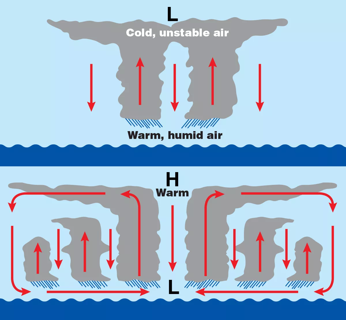
Edouard illustrates the weak end of this process. Its winds never climbed far past the depression threshold before it merged with a frontal boundary, and its pressure only dropped to 1005 millibars. By contrast, a vigorous depression over very warm water and calm winds can intensify into a hurricane within a day or two - a transition forecasters watch closely.
Edouard's Place in a Record-Breaking Season
Edouard was just the opening act of the hyperactive 2020 Atlantic hurricane season, which produced a record 30 named storms, 14 hurricanes, and a record-tying seven major hurricanes. The season was so busy that forecasters exhausted the standard name list and turned to the Greek alphabet for only the second time in history.
Edouard itself was a "fish storm" - a system that stayed over open water and never made landfall. Its only notable impact while tropical was a burst of gusty winds as it passed near Bermuda. That is typical of many tropical depressions and weak tropical storms: they can form, churn harmlessly over the ocean, and dissipate without ever threatening land.
What Happens Next: From Depression to Hurricane
Once a tropical depression forms, forecasters at the NHC begin issuing advisories with its position, intensity, and forecast track. The next milestones are well defined: sustained winds of 39 mph earn the system a name (making it a tropical storm), and 74 mph make it a hurricane, categorized on the five-level Saffir-Simpson Hurricane Wind Scale.
Names are drawn from six rotating lists maintained by the World Meteorological Organization. Edouard - the French form of Edward - is the fifth name on the Atlantic list, following Arthur, Bertha, Cristobal, and Dolly. Unless a name is retired after a particularly deadly or costly storm, it returns every six years; because Edouard was a weak, short-lived storm, the name remains in rotation for future seasons.
For anyone tracking the tropics, the takeaway is simple: not every depression becomes a disaster, but every hurricane begins as one. Watching for the conditions that turn a tropical depression into something stronger is the foundation of hurricane forecasting.
Key Takeaways
- A tropical depression is a tropical cyclone with sustained winds of 38 mph (62 km/h) or less - the weakest official classification.
- It sits between a tropical disturbance and a tropical storm (39-73 mph); at 74 mph, it becomes a hurricane.
- Tropical Depression Edouard formed July 4, 2020, and became Tropical Storm Edouard on July 6, making it the earliest fifth named Atlantic storm on record.
- Tropical depressions need warm ocean water (80 degrees F or warmer), moisture, light wind shear, and the Coriolis effect to form and strengthen.
- Edouard was a weak, short-lived "fish storm" whose remnants went on to bring rain to western Europe.