A nor'easter is a powerful storm that develops along the East Coast of North America, named for the strong winds that blow from the northeast over coastal areas as the system churns offshore. If you have ever heard a forecaster warn of an approaching nor'easter and wondered what separates it from an ordinary winter storm — or how one forms and why it can bury cities in snow while pounding the shore with hurricane-force winds — you are far from alone. These massive extratropical cyclones are among the most dramatic weather events in the United States, and the worst of them have caused billions of dollars in damage. Here is a clear, factual look at what a nor'easter is, how it forms, and what it can do.
What Exactly Is a Nor'easter?
A nor'easter is a large-scale extratropical cyclone — a rotating storm system that forms outside the tropics — in the western North Atlantic Ocean. It takes its name from the direction of its winds: as the storm sits offshore, its counterclockwise circulation drives strong winds out of the northeast and onto the coast. That northeasterly flow is the storm's calling card, and it is the reason the name has stuck for centuries.
These storms typically develop in the latitudes between Georgia and New Jersey, within roughly 100 miles east or west of the East Coast. From there they track generally northeastward, usually reaching their maximum intensity near New England and the Maritime Provinces of Canada. According to the National Weather Service, nor'easters can occur at any time of year but are most frequent and most violent between September and April.
The heavily populated corridor between Washington, D.C., Philadelphia, New York City, and Boston — the “I-95 Corridor” — is especially vulnerable. The term itself has deep maritime roots: it reached American English by way of British English, and the Oxford English Dictionary traces the first recorded use of “nor'easter” to 1837, descended from old compass abbreviations such as “nor'-east” and “noreast” that appear on compass cards as far back as 1607.
How a Nor'easter Forms: When Arctic Cold Meets the Gulf Stream
Nor'easters are born from a collision of two very different air masses. During winter, the polar jet stream carries cold, dry Arctic air southward across Canada and the United States. At the same time, warm, moist air over the Atlantic Ocean tries to push northward. The two meet along the East Coast, and the sharp temperature contrast between them is the engine that powers the storm.
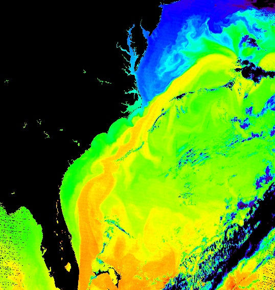
The warm waters of the Gulf Stream are the key ingredient. Even in the middle of winter, Gulf Stream water can hover near 70°F (21°C), keeping the coastal ocean relatively mild. When very cold air rushes over this warm water, low-pressure areas form and rapidly intensify. Higher up, the jet stream whisks rising air away faster than it can be replaced near the surface — and, combined with the Coriolis force, this spins the system into a strong, organized cyclone.
Once formed, the storm's counterclockwise winds push moist Atlantic air over land, where it meets the cold air flowing south from Canada. The larger the temperature difference between the two air masses, the greater the storm's instability and severity. The nor'easter then tracks northeastward along the coast — typically from North Carolina toward Long Island and then east toward the waters off Cape Cod — strengthening as it goes and often peaking offshore of Canada.
Meteorologists sort these storms using the Miller classification, created by J.E. Miller in 1946. “Type A” storms form in the Gulf of Mexico or along the Georgia and South Carolina coast and deliver heavy snow to the inland South, Mid-Atlantic, New England, and Atlantic Canada. “Type B” storms begin as a parent low over the Ohio Valley that redevelops over the Gulf Stream off North Carolina or Virginia, spreading wintry precipitation from the Great Plains and Ohio River Valley to the Mid-Atlantic and New England.
Notable Nor'easters: A Timeline of Historic Storms
Nor'easters have shaped the history of the East Coast for well over a century. Some of the most infamous include:
- The Blizzard of 1888: A legendary storm that paralyzed the Northeast with several feet of snow and hurricane-force winds.
- The “Ash Wednesday” Storm (March 1962): A slow-moving nor'easter that battered the coast for days, causing devastating flooding and erosion.
- The New England Blizzard (February 1978): A powerful storm that dumped record snow across New England and the Northeast.
- The March 1993 “Superstorm”: A sprawling system that brought blizzard conditions from the Gulf Coast all the way to New England.
- The Boston Snowstorms (January–February 2015): A relentless series of storms that buried the city in record seasonal snowfall.
More recent examples — including the blizzard of 2006, the February 2013 blizzard, and the January 2018 blizzard — showed that the most intense nor'easters can take on the circular shape of a hurricane, complete with a small dry slot near the center that is sometimes mistaken for an eye.
Why Nor'easters Pack Such a Punch
What makes a nor'easter so dangerous is its combination of hazards in a single event. The National Weather Service notes that these storms nearly always bring heavy rain or snow, gale-force winds, rough seas, and — in the worst cases — disastrous coastal flooding. Wind gusts can reach hurricane strength, and all precipitation types, from torrential downpours to fine mist to heavy snow, can occur within a single storm.
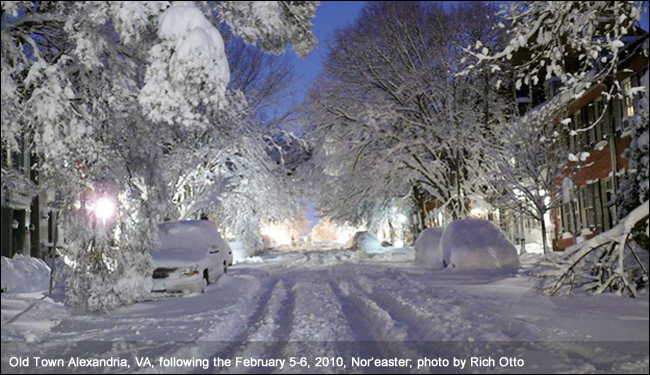
The economic toll is enormous. Past nor'easters have been responsible for billions of dollars in damage, along with severe disruption to transportation and daily life, and the cost of the worst storms can exceed a billion dollars on their own.
People often confuse nor'easters with tropical cyclones, but the two are fundamentally different. Hurricanes are “warm-core” systems that draw energy from warm ocean water and thrive on uniform warmth. Nor'easters are “cold-core” low-pressure systems that thrive on sharp temperature contrasts — the very difference between cold land air and the warm Gulf Stream. That is why nor'easters form in fall and winter, while hurricanes peak in late summer.
When Nor'easters Strike: Season and Where They Hit
Nor'easters can form at any time of year, but they are overwhelmingly a cold-season phenomenon. They are most frequent and most powerful between September and April, with the strongest storms typically developing between November and March, when the contrast between Arctic air and the still-warm Atlantic is greatest. The upper North Atlantic coast of the United States and the Atlantic Provinces of Canada are generally hit by nor'easters a few times each winter.

Some storms stay just offshore and clip the coast with wind and snow, while others move slightly inland and bring rain to coastal cities such as New York, Philadelphia, and Baltimore while burying New England under snow. On occasion, a nor'easter can pull cold air as far south as Virginia or North Carolina, briefly turning rain to wet snow there as well.
How Forecasters Track Nor'easters and How to Prepare
Forecasters at National Weather Service offices and the National Centers for Environmental Prediction monitor conditions that favor nor'easters, especially in fall and winter. When a nor'easter looks likely, they issue winter storm, blizzard, high wind, and coastal flood watches — upgrading them to warnings as the threat becomes imminent.
Preparation makes a real difference. The National Weather Service recommends keeping a disaster supplies kit with at least three days of food, water, and other provisions, since a nor'easter can knock out power and leave you in the dark. It also advises creating a family emergency communications plan so loved ones know how to stay in touch if separated, staying off the roads when local authorities ask, and never driving into floodwaters.
Nor'easter Essentials: The Bottom Line
- A nor'easter is a large extratropical cyclone along the U.S. East Coast, named for its northeasterly winds.
- It forms when cold Arctic air collides with warm, moist air over the Gulf Stream, most often between September and April.
- Nor'easters bring heavy rain or snow, hurricane-force wind gusts, rough seas, and coastal flooding — sometimes all at once.
- The I-95 Corridor, from Washington, D.C. to Boston, is especially vulnerable.
- Unlike hurricanes, nor'easters are cold-core systems fueled by temperature contrasts, not warm water alone.
- The worst storms — from the Blizzard of 1888 to the March 1993 Superstorm — have caused billions of dollars in damage.