
On April 20, 2026, a powerful 7.4 magnitude earthquake struck off the coast of northeastern Japan, triggering tsunami warnings for multiple prefectures and sending waves up to 80 centimeters (2.6 feet) ashore. While the immediate warnings were eventually lifted, the event served as a stark reminder of Japan's position in one of the world's most active seismic zones. But what causes these frequent earthquakes, and how does Japan's sophisticated warning system work to protect millions of people? This article breaks down the science behind earthquakes, the technology that provides precious seconds of warning, and how tsunamis are detected and monitored.
The Geological Forces Behind Japan's Frequent Earthquakes
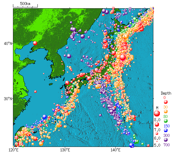
Japan sits at a precarious crossroads of Earth's tectonic plates. The country is positioned directly over the meeting point of four major plates: the Pacific Plate, the North American Plate, the Eurasian Plate, and the Philippine Sea Plate. This complex geological setting places Japan within the Pacific "Ring of Fire," a horseshoe-shaped belt around the Pacific Ocean that accounts for roughly 90% of the world's earthquakes and 75% of its active volcanoes.
The relentless movement of these massive slabs of Earth's crust creates immense pressure along their boundaries. When the stress exceeds the strength of the rocks, they suddenly slip or break, releasing energy in the form of seismic waves—an earthquake. The type of plate interaction matters greatly. In Japan's case, the Pacific Plate is slowly but forcefully diving beneath the North American Plate in a process called subduction. This ongoing collision is responsible for some of the most powerful and tsunamigenic earthquakes in history, including the devastating 2011 Tohoku earthquake.
How Japan's Earthquake Early Warning System Works
Japan's Earthquake Early Warning (EEW) system is one of the most advanced in the world, designed to provide crucial seconds of advance notice before strong shaking arrives. The system leverages a fundamental property of seismic waves: they travel at different speeds. When an earthquake occurs, it generates two main types of body waves—P-waves (primary waves) and S-waves (secondary waves). P-waves are faster but cause less damage, while slower S-waves carry the destructive shaking.
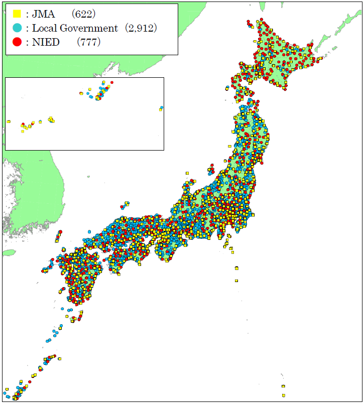
The Japan Meteorological Agency (JMA) operates a dense network of over 4,000 seismometers across the country, including approximately 200 high-sensitivity seismographs and 600 seismic intensity meters, plus data from 3,600 additional instruments managed by local governments. When these sensors detect the initial P-waves, the data is instantly transmitted to JMA's processing centers. Sophisticated algorithms rapidly analyze the information to estimate the earthquake's location, magnitude, and which areas will experience strong shaking.
If the estimated seismic intensity is expected to reach 5 or higher on Japan's 7-point scale, the system automatically issues warnings through multiple channels within seconds—often before the more destructive S-waves arrive. These alerts are broadcast on television and radio, sent to smartphones via dedicated apps and cellular networks, and trigger public address systems. This gives people precious time to take protective actions: dropping to the floor, taking cover under sturdy furniture, and holding on until the shaking stops.
From Earthquake to Tsunami: How Oceanic Disasters Are Born
Not every earthquake generates a tsunami, but certain conditions make them particularly likely. The most dangerous tsunamis are typically created by large earthquakes occurring at subduction zones—exactly the type of tectonic setting found off Japan's coast. When one tectonic plate suddenly slips beneath another during a major earthquake, it can vertically displace enormous sections of the seafloor, sometimes by several meters.
This sudden uplift or subsidence of the ocean floor pushes the entire water column above it, creating a series of waves that radiate outward in all directions. In the deep ocean, these waves may travel at speeds exceeding 800 kilometers per hour (500 mph) but with heights of only a few centimeters, making them virtually undetectable to ships. As the waves approach shallower coastal waters, they slow down and their energy becomes concentrated, causing the wave height to grow dramatically—sometimes reaching tens of meters by the time they reach shore.
Japan's Tsunami Warning System: Minutes That Save Lives
Following the detection of a significant earthquake, Japan's tsunami warning system springs into action with remarkable speed. The JMA aims to issue initial tsunami warnings within two to three minutes of the quake. This rapid response is possible because the agency uses the earthquake's characteristics—particularly its magnitude, depth, and location—to make initial tsunami predictions.
The system analyzes whether the earthquake occurred under the ocean, its estimated magnitude (generally earthquakes below magnitude 6.5 rarely generate dangerous tsunamis), and the mechanism of faulting. Earthquakes that involve vertical movement of the seafloor are more likely to displace large volumes of water. Based on this analysis, JMA issues one of three levels of alerts: Tsunami Warning (expecting waves over 3 meters), Tsunami Advisory (expecting waves up to 1 meter), or Tsunami Forecast (no significant waves expected).
To refine these initial estimates, Japan also maintains a network of ocean-based tsunami detection systems. These include offshore tsunami meters placed on the seafloor that can detect pressure changes caused by passing tsunami waves, as well as GPS buoys that measure sea surface height. Data from these instruments helps confirm whether a tsunami has actually been generated and provides more accurate estimates of wave heights and arrival times for specific coastal locations.
The April 2026 Earthquake: A Case Study in Action
The recent 7.4 magnitude earthquake that struck off Japan's northeastern coast on April 20, 2026, provides a real-world example of these systems in action. According to the U.S. Geological Survey, the quake occurred at a depth of approximately 40 kilometers (25 miles) beneath the Pacific Ocean, about 100 kilometers east of the Iwate prefecture coast. Within seconds, Japan's Earthquake Early Warning system detected the initial tremors and issued alerts across affected regions.
Approximately two minutes later, the JMA issued tsunami warnings for Iwate, Aomori, and Hokkaido prefectures, advising residents in coastal areas to evacuate to higher ground. About 40 minutes after the earthquake, an 80-centimeter (2.6-foot) tsunami wave was recorded at the port of Kuji in Iwate prefecture. While this wave height was significantly smaller than initially feared, it demonstrated the accuracy of Japan's detection capabilities. The warnings were eventually downgraded and lifted after confirming that no larger waves were approaching.
In the aftermath, JMA officials noted that the earthquake occurred in the same general region as the devastating 2011 Tohoku earthquake, though on a different segment of the subduction zone. They warned of a slightly increased probability of another large earthquake in the region within the following week, highlighting the complex and ongoing nature of seismic risk in subduction zones.
What to Do When Warnings Sound: Life-Saving Actions
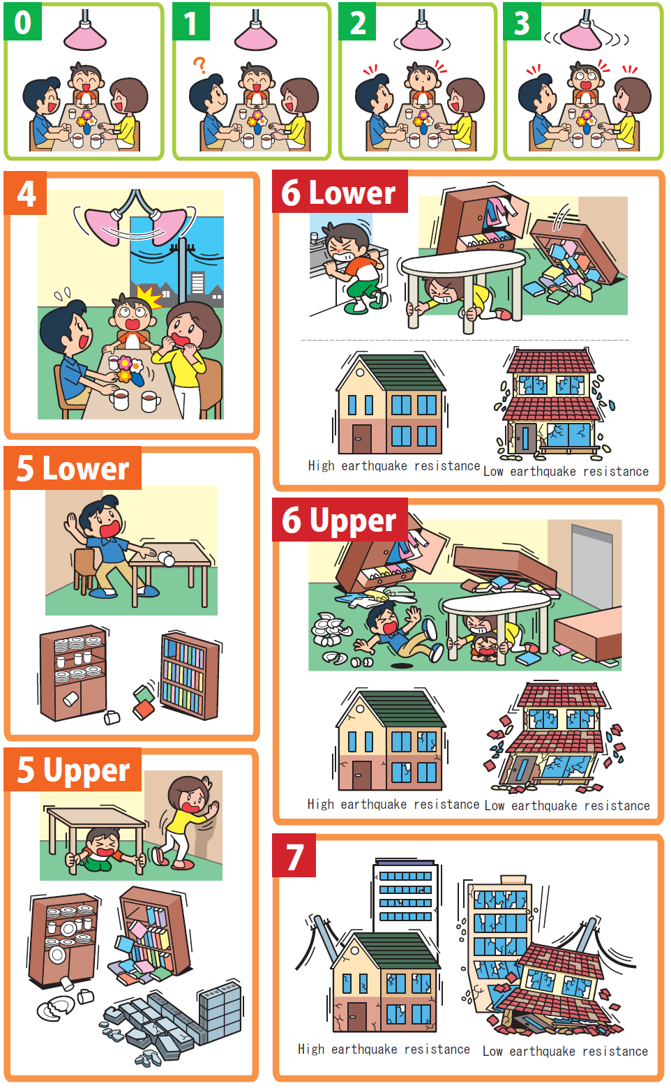
Japan's sophisticated warning systems are only effective if people know how to respond. When an Earthquake Early Warning alert sounds, the recommended action is simple: Drop, Cover, and Hold On. Immediately drop to your hands and knees to prevent being knocked down, take cover under a sturdy piece of furniture like a table, and hold on until the shaking stops. Avoid doorways (they offer no protection in modern buildings) and stay away from windows that could shatter.
If a tsunami warning is issued after an earthquake, the rule is equally clear: Evacuate immediately to high ground or an upper floor of a reinforced concrete building. Do not wait to see the wave—tsunamis can arrive within minutes in some locations. Move on foot if possible, as roads may be damaged or congested with traffic. Once in a safe location, stay there until officials declare the all-clear, as tsunamis often arrive as a series of waves, with later waves sometimes being larger than the first.
The Future of Earthquake and Tsunami Warning Technology
Japan continues to refine its early warning capabilities through ongoing research and technological innovation. Scientists are working on methods to provide even faster earthquake detection by analyzing the very earliest seismic signals. Other research focuses on using artificial intelligence to improve the accuracy of magnitude estimates and tsunami predictions. There's also growing interest in developing more localized warning systems that can provide hyper-specific alerts for individual communities based on their unique geological conditions.
Internationally, Japan shares its technology and expertise through organizations like the UNESCO Intergovernmental Oceanographic Commission, helping other tsunami-prone regions around the world develop their own warning systems. This global collaboration is crucial, as tsunamis generated anywhere in the Pacific Ocean can potentially affect coastlines thousands of kilometers away.
The recent earthquake off Japan's coast serves as both a reminder of the planet's dynamic nature and a testament to how scientific understanding and technological innovation can mitigate natural disasters. While we cannot prevent earthquakes, systems that provide even seconds of warning—and the public education that ensures people know how to respond—can make the difference between safety and catastrophe in one of the world's most seismically active regions.