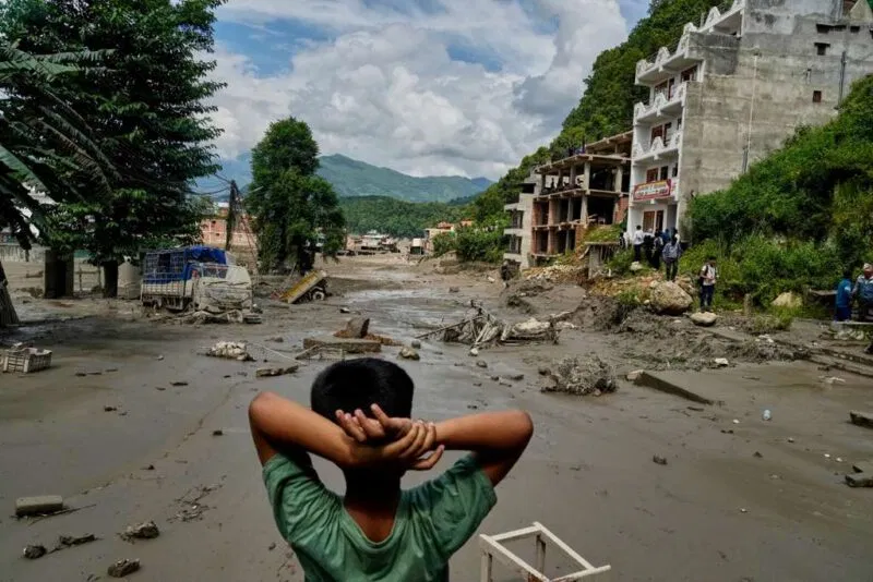
Nepal is a landlocked country in South Asia, sandwiched between China's Tibet region to the north and India to the south, east, and west — and in late August 2026 it was struck by one of the deadliest flash flood disasters in its recent history. On August 26, 2026, a glacier collapsed high in the Himalayas near the Nepal–China border, unleashing a wall of water and mud that tore down river valleys, killing at least 300 people and leaving more than 1,400 missing. This article answers the questions people are searching for right now — where is Nepal, what caused the floods, and how does a glacier collapse turn into a flash flood — while explaining why scientists say climate change is making these disasters more likely.
Where Is Nepal? A Small Country With Extreme Geography
Nepal lies between China and India in South Asia and is roughly the size of the U.S. state of Arkansas — about 147,516 square kilometres (56,956 square miles). It stretches roughly 880 kilometres (547 miles) along the Himalayan axis but is only 150 to 250 kilometres (93 to 155 miles) wide. Despite its modest size, Nepal has the greatest altitude change of any country on Earth: it climbs from the lowland Terai plains at around 60 metres (200 feet) above sea level to the summit of Mount Everest at 8,848 metres (29,029 feet), the highest point on the planet.
That extreme vertical relief matters for the floods. Nepal is traditionally divided into three geographic belts that step upward from south to north: the Terai, a flat, fertile lowland bordering India; the Hills, a rugged midland region where most people live; and the Himalaya, the snow-and-ice range that forms the border with Tibet. It is this steep, icy northern belt — and the thousands of glaciers and glacial lakes it holds — that makes the country so vulnerable to sudden, catastrophic flooding.
What Happened: A Glacier Collapse Sent a Wall of Water Downstream
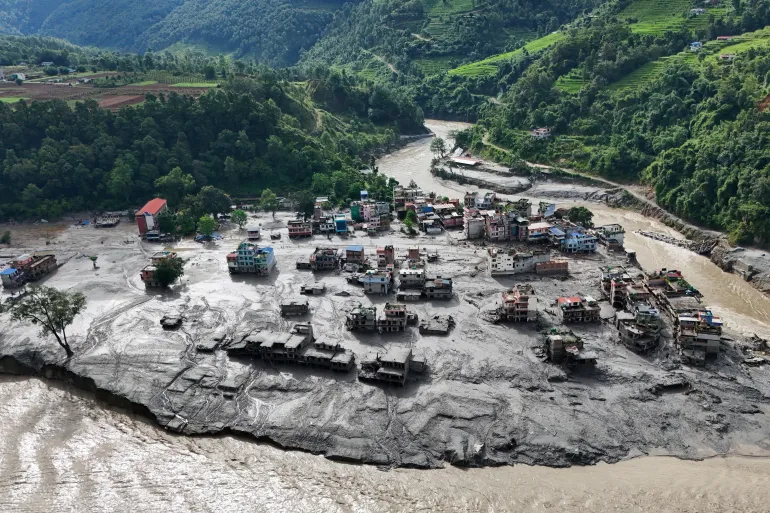
On the morning of August 26, 2026, a massive flash flood surged through the Bhotekoshi River in Rasuwa district near the Nepal–China border, sweeping away buildings, vehicles, roads and bridges. Witnesses said the waters engulfed entire villages, and water levels in the Trishuli River reportedly rose by as much as 9 metres (27 feet) in just 30 minutes.
There was initial confusion about the cause, with some officials suggesting an earthquake. But scientists now agree the disaster began with a glacier collapse. Dave Petley, a leading landslide expert who runs the Landslide Blog at the American Geophysical Union's EOS magazine, explained: "The catastrophic debris flow that struck Nepal and Tibet today was triggered by the collapse of a glacier high in the mountains." Petley added that the seismic signal picked up on instruments was "almost certainly the rock-ice avalanche and debris flow, not a tectonic event."
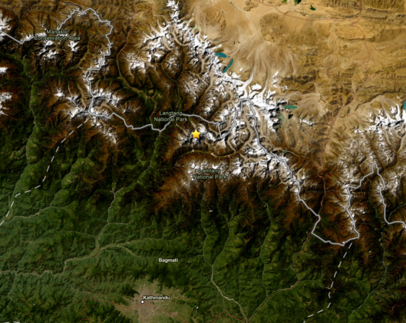
The U.S. Geological Survey recorded the collapse as the equivalent of a magnitude 5.2 event on local seismometers, at 2:52:10 UTC (8:37 a.m. Nepal time), roughly 55 kilometres northwest of Kodari, Nepal. Nepal's National Disaster Risk Reduction and Management Authority described a "glacier-inclusive flood" in the Lhende River, triggered by "an ice-rock avalanche on the Nepali side."
How Does a Glacier Collapse Turn Into a Flash Flood?
To understand the disaster, it helps to know the two main ways Himalayan ice can unleash floods. The first is a glacial lake outburst flood, or GLOF. As glaciers retreat, meltwater can pool behind dams of loose rock and debris called moraines; when one of these dams fails — from an earthquake, an avalanche or rising water pressure — the lake drains catastrophically, sending a torrent downstream.
The second is a glacier collapse, or ice-rock avalanche, which is what scientists say happened in August 2026. Dan Shugar, an associate professor at the University of Calgary, said satellite imagery suggested a large amount of snow melted in the 24 hours before the disaster, and that "the lower part of a glacier broke off at about 5,200 metres and crashed onto the valley floor about 1,200 metres below." The enormous energy of that fall can melt ice into water while the tumbling mass picks up rock, sediment and river water, creating a fast-moving slurry of mud and debris that one hydrologist compared to "liquid concrete."
Hatim Sharif, a hydrologist at the University of Texas at San Antonio, noted a crucial detail: there was little rainfall beforehand, which "defeats essentially every operational flood warning system in the world." By the time people saw the mud coming, he said, running or driving away would not have helped.
Timeline: How the Disaster Unfolded
- August 26, 2026, 2:52 a.m. UTC (8:37 a.m. Nepal time): A glacier collapses on the north side of Langtang-Lirung mountain near the Nepal–Tibet border, registering as a magnitude 5.2 landslide on seismometers.
- Within minutes: The collapse sends a debris-laden flood surging down the Lhende Khola into the Bhote Koshi and Trishuli rivers, through Rasuwa and Nuwakot districts.
- August 26–27: Rescue operations begin as villages, roads and bridges are swept away; the death toll climbs past 300, with more than 1,400 people reported missing across Nepal and Tibet.
- August 27: Nepal's disaster authority and scientists including Dave Petley and Dan Shugar identify a glacier collapse — not an earthquake — as the trigger.
Why Climate Change Is Raising the Risk
Scientists caution that it is too soon to say conclusively that global warming caused this specific collapse, but the broader trend is unmistakable. Glaciers across the Hindu Kush Himalaya — the range stretching from Afghanistan to Myanmar that includes Nepal — lost ice 65 percent faster between 2011 and 2020 than in the previous decade. According to the United Nations, Nepal's glaciers have shed close to one-third of their ice volume in roughly three decades.
Dorothy Heinrich, a researcher at the U.K.'s University of Reading, said warming drives "glacial retreat, permafrost reduction" and other changes that "can drive things like landslides and glacial outburst floods." Warmer temperatures melt the ice and snow that hold steep mountain slopes together, making glacier collapses and rock-ice avalanches more likely — and raising the stakes for the millions of people living in the valleys below.
This is not the first time a Himalayan glacier has collapsed. In July 2016, about 68 million cubic metres of ice detached from a glacier in Tibet's Aru Range, killing nine herders; a second collapse two months later released 83 million cubic metres. In 2018, a rock-and-ice avalanche from Ronti Peak in India's Uttarakhand killed more than 200 people. Each event is a reminder of how quickly mountain ice can turn lethal.
Where Things Stand Now
As of August 27, 2026, Nepali authorities reported at least 359 people killed in the Himalayan flash floods, with more than 1,400 still missing, according to Al Jazeera's live coverage. Search-and-rescue teams continued working through difficult terrain, while dramatic footage showed workers narrowly escaping the torrents. The true toll is likely to rise as remote areas are reached.
For survivors, the losses are deeply personal. Keshav Prasad Baral, a 68-year-old being treated in hospital, described a "huge gush of mud coming straight towards us." As it rose higher and entered his home, he tried to grab his wife's hand, but "she was swept away by the mud."
What Happens Next
Scientists say fully understanding this event will require an international team, as with similar disasters in recent years. Dave Petley wrote that the team "has now got together and has started work," studying the source of the enormous volume of water and the mechanics of the collapse. Meanwhile, experts say the disaster underscores the urgent need for better early-warning systems — even though the lack of rainfall shows how hard these glacier-driven floods are to predict. As the Himalayas keep warming, monitoring glacial lakes and unstable ice is becoming a matter of life and death for communities downstream.
Key Takeaways
- Nepal is a landlocked country in South Asia between China and India, with the greatest altitude range of any nation — from the Terai plains to Mount Everest.
- The August 26, 2026, flash floods were triggered by a glacier collapse, not an earthquake, near the Nepal–China border.
- The flood swept through the Bhote Koshi and Trishuli rivers, killing at least 300 people and leaving more than 1,400 missing.
- Climate change is rapidly melting Himalayan glaciers, increasing the risk of glacial lake outburst floods and glacier collapses.